
Carte topographique Pico Grande
Carte interactive
Cliquez sur la carte pour afficher l’altitude.
À propos de cette carte
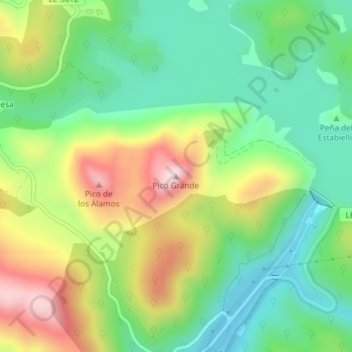
Nom : Carte topographique Pico Grande, altitude, relief.
Lieu : Pico Grande, Boñar, León, Castilla y León, 24853, España (42.93059 -5.30870 42.93069 -5.30860)
Altitude moyenne : 1 159 m
Altitude minimum : 1 019 m
Altitude maximum : 1 388 m
Autres cartes topographiques
Cliquez sur une carte pour visualiser sa topographie, son altitude et son relief.
Embalse del Porma
España > Castilla y León > Boñar
Embalse del Porma, Boñar, Montaña de Riaño, León, Castilla y León, España
Altitude moyenne : 1 126 m