
Faire un don
Équipez-vous pour votre prochaine aventure :
En tant que Partenaire Amazon, ce site perçoit une commission sur les achats éligibles sans surcoût pour vous.
Carte topographique Mashpee
Cliquez sur la carte pour afficher l’altitude.
Faire un don
Équipez-vous pour votre prochaine aventure :
En tant que Partenaire Amazon, ce site perçoit une commission sur les achats éligibles sans surcoût pour vous.
Mashpee
Like all towns on the Cape, Mashpee's topography is that of sandy soil, small ponds and inlets, surrounded by the pines and oaks indigenous to the area. The town's shoreline is framed by Waquoit Bay to the west and Popponesset Bay to the east, with several rivers, brooks and small ponds in the area. The town contains South Cape Beach State Park along Dead Neck and Waquoit Bay, and the Lowell Holly Reservation, comprising the land between Wakeby and Mashpee Ponds.
Faire un don
Équipez-vous pour votre prochaine aventure :
En tant que Partenaire Amazon, ce site perçoit une commission sur les achats éligibles sans surcoût pour vous.
À propos de cette carte
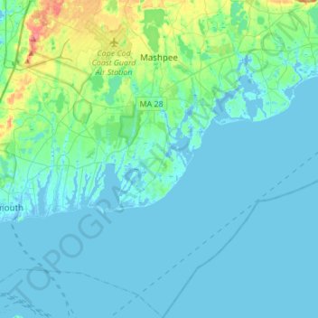
Nom : Carte topographique Mashpee, altitude, relief.
Altitude moyenne : 10 m
Altitude minimum : -11 m
Altitude maximum : 72 m
Faire un don
Équipez-vous pour votre prochaine aventure :
En tant que Partenaire Amazon, ce site perçoit une commission sur les achats éligibles sans surcoût pour vous.
Autres cartes topographiques
Cliquez sur une carte pour visualiser sa topographie, son altitude et son relief.
Opeechee Heights Beach
United States > Massachusetts > Barnstable County > Barnstable > Centerville
Altitude moyenne : 14 m
Faire un don
Équipez-vous pour votre prochaine aventure :
En tant que Partenaire Amazon, ce site perçoit une commission sur les achats éligibles sans surcoût pour vous.
Faire un don
Équipez-vous pour votre prochaine aventure :
En tant que Partenaire Amazon, ce site perçoit une commission sur les achats éligibles sans surcoût pour vous.
Bourne Corners
United States > Massachusetts > Barnstable County > Bourne > Buzzards Bay
Altitude moyenne : 9 m
Gray Gables
United States > Massachusetts > Barnstable County > Bourne > Buzzards Bay
Altitude moyenne : 5 m
Faire un don
Équipez-vous pour votre prochaine aventure :
En tant que Partenaire Amazon, ce site perçoit une commission sur les achats éligibles sans surcoût pour vous.
Faire un don
Équipez-vous pour votre prochaine aventure :
En tant que Partenaire Amazon, ce site perçoit une commission sur les achats éligibles sans surcoût pour vous.
West Barnstable
United States > Massachusetts > Barnstable County > West Barnstable
Altitude moyenne : 15 m
Faire un don
Équipez-vous pour votre prochaine aventure :
En tant que Partenaire Amazon, ce site perçoit une commission sur les achats éligibles sans surcoût pour vous.
Faire un don
Équipez-vous pour votre prochaine aventure :
En tant que Partenaire Amazon, ce site perçoit une commission sur les achats éligibles sans surcoût pour vous.
Washburn Island
United States > Massachusetts > Barnstable County > Falmouth > Menauhant
Altitude moyenne : 1 m
Faire un don
Équipez-vous pour votre prochaine aventure :
En tant que Partenaire Amazon, ce site perçoit une commission sur les achats éligibles sans surcoût pour vous.
Faire un don
Équipez-vous pour votre prochaine aventure :
En tant que Partenaire Amazon, ce site perçoit une commission sur les achats éligibles sans surcoût pour vous.
Faire un don
Équipez-vous pour votre prochaine aventure :
En tant que Partenaire Amazon, ce site perçoit une commission sur les achats éligibles sans surcoût pour vous.
Bournedale
United States > Massachusetts > Barnstable County > Bourne > Bournedale
Altitude moyenne : 29 m
Barnstable
United States > Massachusetts > Barnstable County > Barnstable > Barnstable
Altitude moyenne : 10 m
Dennis Port
United States > Massachusetts > Barnstable County > Dennis > Dennis Port
Altitude moyenne : 3 m
Faire un don
Équipez-vous pour votre prochaine aventure :
En tant que Partenaire Amazon, ce site perçoit une commission sur les achats éligibles sans surcoût pour vous.