
Carte topographique Wareham
Carte interactive
Cliquez sur la carte pour afficher l’altitude.
À propos de cette carte
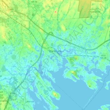
Nom : Carte topographique Wareham, altitude, relief.
Lieu : Wareham, Plymouth County, Massachusetts, United States (41.68954 -70.78169 41.82578 -70.61663)
Altitude moyenne : 12 m
Altitude minimum : -7 m
Altitude maximum : 66 m
Wareham was first settled in 1678 by Europeans as part of the towns of Plymouth and Rochester. It was officially incorporated in 1739 and named after the town of Wareham in England. Because of its geography, Wareham's early industry revolved around shipbuilding and the related industries. It also served as a resort town, with many smaller resorts scattered around the town, especially in Onset. Like Sandwich, its waterways, especially Buttermilk Bay, were considered as possible pathways for the Cape Cod Canal. Although the canal proper goes through Bourne and Sandwich, the southern approach to Buzzards Bay passes just south of the peninsulas that make up the topography of the town.
Autres cartes topographiques
Cliquez sur une carte pour visualiser sa topographie, son altitude et son relief.
Oakdale
United States > Massachusetts > Wareham > Oakdale
Oakdale, Wareham, Plymouth County, Massachusetts, 02571, United States
Altitude moyenne : 6 m