
Carte topographique Karimala
Carte interactive
Cliquez sur la carte pour afficher l’altitude.
À propos de cette carte
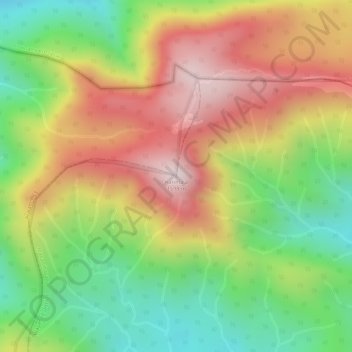
Nom : Carte topographique Karimala, altitude, relief.
Lieu : Karimala, Mananthavady, Wayanad District, Kerala, India (11.93413 75.93655 11.93423 75.93665)
Altitude moyenne : 1 324 m
Altitude minimum : 1 058 m
Altitude maximum : 1 584 m
Autres cartes topographiques
Cliquez sur une carte pour visualiser sa topographie, son altitude et son relief.
Palvelicham
India > Kerala > Mananthavady
Palvelicham, Mananthavady, Wayanad District, Kerala, India
Altitude moyenne : 735 m
Dwaraka
India > Kerala > Mananthavady
Dwaraka, Mananthavady, Wayanad District, Kerala, 670732, India
Altitude moyenne : 746 m
Thirunelli
India > Kerala > Mananthavady
Thirunelli, Mananthavady, Wayanad District, Kerala, India
Altitude moyenne : 969 m
Anjukunnu
India > Kerala > Mananthavady
Anjukunnu, Mananthavady, Wayanad, Kerala, 670732, India
Altitude moyenne : 745 m
Kattimoola
India > Kerala > Mananthavady
Kattimoola, Mananthavady, Wayanad, Kerala, 670644, India
Altitude moyenne : 753 m
nedumblassery colony
India > Kerala > Mananthavady
nedumblassery colony, Mananthavady, Wayanad District, Kerala, 670731, India
Altitude moyenne : 758 m
Panamaram
India > Kerala > Mananthavady > Panamaram
Panamaram, Mananthavady, Wayanad, Kerala, 670721, India
Altitude moyenne : 736 m
Thavinhal
India > Kerala > Mananthavady > Boy's Town
Thavinhal, Boy's Town, Mananthavady, Wayanad, Kerala, India
Altitude moyenne : 690 m