
Carte topographique Okanogan County
Carte interactive
Cliquez sur la carte pour afficher l’altitude.
À propos de cette carte
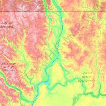
Nom : Carte topographique Okanogan County, altitude, relief.
Lieu : Okanogan County, Washington, United States of America (47.94081 -120.88572 49.00057 -118.83520)
Altitude moyenne : 1 076 m
Altitude minimum : 217 m
Altitude maximum : 2 704 m
Autres cartes topographiques
Cliquez sur une carte pour visualiser sa topographie, son altitude et son relief.
SeaTac
United States of America > Washington > SeaTac
SeaTac, King County, Washington, United States of America
Altitude moyenne : 60 m
Bellevue
United States of America > Washington > Bellevue
Bellevue, King County, Washington, 98004-4452, United States of America
Altitude moyenne : 88 m
Bellingham
United States of America > Washington > Bellingham
Bellingham, Whatcom County, Washington, United States of America
Altitude moyenne : 89 m
Yakima
United States of America > Washington > Yakima
Yakima, Yakima County, Washington, United States of America
Altitude moyenne : 377 m
Lewis County
United States of America > Washington
Lewis County, Washington, United States of America
Altitude moyenne : 558 m
Clallam County
United States of America > Washington
Clallam County, Washington, United States of America
Altitude moyenne : 335 m
Thurston County
United States of America > Washington
Thurston County, Washington, United States of America
Altitude moyenne : 150 m
Wahkiakum County
United States of America > Washington
Wahkiakum County, Washington, United States of America
Altitude moyenne : 246 m