
Carte topographique New South Wales
Carte interactive
Cliquez sur la carte pour afficher l’altitude.
À propos de cette carte
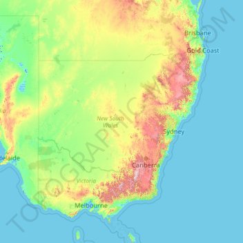
Nom : Carte topographique New South Wales, altitude, relief.
Lieu : New South Wales, Australia (-37.52801 140.99926 -28.14153 159.33903)
Altitude moyenne : 154 m
Altitude minimum : -6 m
Altitude maximum : 2 129 m
The climate in the southern half of the state is generally warm to hot in summer and cool in the winter. The seasons are more defined in the southern half of the state, especially as one moves inland towards South West Slopes, Central West and the Riverina region. The climate in the northeast region of the state, or the North Coast, bordering Queensland, is hot and humid in the summer and mild in winter. The Northern Tablelands, which are also on the North coast, have relatively mild summers and cold winters, due to their high elevation on the Great Dividing Range.
Autres cartes topographiques
Cliquez sur une carte pour visualiser sa topographie, son altitude et son relief.
Clyde North
Australia > Victoria > Melbourne
Clyde North, Melbourne, City of Casey, Victoria, 3978, Australia
Altitude moyenne : 38 m
Armstrong Beach
Armstrong Beach, Mackay Regional, Queensland, Australia
Altitude moyenne : 10 m
Bridgetown
Bridgetown, Shire Of Bridgetown-Greenbushes, Western Australia, 6255, Australia
Altitude moyenne : 223 m
Warrill View
Warrill View, Scenic Rim Regional, Queensland, Australia
Altitude moyenne : 82 m
Frances
Frances, Hinchinbrook Shire, Queensland, Australia
Altitude moyenne : 76 m
Castle Head
Castle Head, Shoalhaven City Council, New South Wales, Australia
Altitude moyenne : 275 m
Revesby Heights
Australia > New South Wales > Sydney
Revesby Heights, Sydney, Canterbury-Bankstown Council, New South Wales, 2212, Australia
Altitude moyenne : 26 m
Daintree Rainforest
Daintree Rainforest, Diwan, Douglas Shire, Queensland, Australia
Altitude moyenne : 59 m
Pewsey Vale
Pewsey Vale, The Barossa Council, South Australia, 5351, Australia
Altitude moyenne : 429 m
Sydney
Sydney, Council of the City of Sydney, New South Wales, Australia
Altitude moyenne : 53 m
Deep Creek Reserve
Australia > New South Wales > Sydney
Deep Creek Reserve, North Narrabeen, Northern Beaches, Sydney, Northern Beaches Council, New South Wales, 2101, Australia
Altitude moyenne : 50 m
Shelly Beach
Australia > Queensland > Sunshine Coast Regional
Shelly Beach, Sunshine Coast Regional, Queensland, Australia
Altitude moyenne : 8 m
Hillbank
Australia > South Australia > Adelaide
Hillbank, Adelaide, City of Playford, South Australia, 5112, Australia
Altitude moyenne : 108 m
Oberon Council
Oberon Council, New South Wales, 2787, Australia
Altitude moyenne : 899 m
Albion Park Rail
Albion Park Rail, Shellharbour City Council, New South Wales, 2527, Australia
Altitude moyenne : 11 m
Cynthia
Cynthia, North Burnett Regional, Queensland, Australia
Altitude moyenne : 220 m
Snapper Island
Australia > New South Wales > Sydney
Snapper Island, Sydney, New South Wales, Australia
Altitude moyenne : 13 m
Jamisontown
Australia > New South Wales > Sydney > Penrith
Jamisontown, Penrith, Sydney, Penrith City Council, New South Wales, 2750, Australia
Altitude moyenne : 35 m
black and white-ruffed lemur
Australia > New South Wales > Mogo
black and white-ruffed lemur, Mogo, Eurobodalla Shire Council, New South Wales, 2536, Australia
Altitude moyenne : 29 m
Shire of Corangamite
Shire of Corangamite, Victoria, Australia
Altitude moyenne : 151 m
Somersby
Australia > New South Wales > Gosford
Somersby, Gosford, Central Coast Council, New South Wales, 2250, Australia
Altitude moyenne : 151 m
Castle Hill
Australia > New South Wales > Sydney
Castle Hill, Sydney, The Hills Shire Council, New South Wales, 2154, Australia
Altitude moyenne : 123 m
Cherry Creek
Cherry Creek, Toowoomba Regional, Queensland, Australia
Altitude moyenne : 414 m
Kogan
Kogan, Western Downs Regional, Queensland, Australia
Altitude moyenne : 344 m
Regentville
Australia > New South Wales > Sydney
Regentville, Sydney, Penrith City Council, New South Wales, 2745, Australia
Altitude moyenne : 37 m
North Perth
North Perth, City Of Vincent, Western Australia, 6006, Australia
Altitude moyenne : 31 m
Maryvale
Maryvale, Southern Downs Regional, Queensland, Australia
Altitude moyenne : 654 m
Anderleigh
Anderleigh, Gympie Regional, Queensland, Australia
Altitude moyenne : 121 m
Willow Grove
Willow Grove, Shire of Baw Baw, Victoria, 3825, Australia
Altitude moyenne : 152 m
West End
West End, Greater Brisbane, Queensland, 4101, Australia
Altitude moyenne : 15 m
Nambung
Nambung, Shire Of Dandaragan, Western Australia, Australia
Altitude moyenne : 60 m
Bringelly
Australia > New South Wales > Sydney
Bringelly, Sydney, Liverpool City Council, New South Wales, 2556, Australia
Altitude moyenne : 87 m
Norries Headland
Norries Headland, Cabarita Hill Walking Track, Cabarita Beach, Tweed Shire Council, New South Wales, 2488, Australia
Altitude moyenne : 2 m
Abergowrie
Abergowrie, Hinchinbrook Shire, Queensland, Australia
Altitude moyenne : 270 m
Richmond
Australia > South Australia > Adelaide
Richmond, Adelaide, City of West Torrens, South Australia, 5033, Australia
Altitude moyenne : 18 m
Cushnie
Cushnie, South Burnett Regional, Queensland, Australia
Altitude moyenne : 426 m
Mount Bartle Frere (South Peak)
Mount Bartle Frere (South Peak), Cairns Regional, Queensland, Australia
Altitude moyenne : 1 276 m
Kosciuszko
Kosciuszko, Snowy Valleys Council, New South Wales, 2627, Australia
Altitude moyenne : 1 434 m
Davies Park
Davies Park, West End, Greater Brisbane, Queensland, 4101, Australia
Altitude moyenne : 16 m
Guilderton
Guilderton, Shire Of Gingin, Western Australia, Australia
Altitude moyenne : 25 m
Hindmarsh Tiers
Australia > South Australia > City of Victor Harbor
Hindmarsh Tiers, City of Victor Harbor, South Australia, 5202, Australia
Altitude moyenne : 297 m
Oyster Bay
Australia > New South Wales > Sydney
Oyster Bay, Sutherland Shire, Sydney, Sutherland Shire Council, New South Wales, 2225, Australia
Altitude moyenne : 25 m