
Faire un don
Équipez-vous pour votre prochaine aventure :
En tant que Partenaire Amazon, ce site perçoit une commission sur les achats éligibles sans surcoût pour vous.
Carte topographique Chittorgarh
Cliquez sur la carte pour afficher l’altitude.
Faire un don
Équipez-vous pour votre prochaine aventure :
En tant que Partenaire Amazon, ce site perçoit une commission sur les achats éligibles sans surcoût pour vous.
Chittorgarh
Chittorgarh is located at 24°53′N 74°38′E / 24.88°N 74.63°E / 24.88; 74.63. It has an average elevation of 394 metres (1292 ft).Chittorgarh is located in the southern part of the state of Rajasthan, in the northwestern part of India. It is located beside a high hill near the Gambhiri River. Chittorgarh is located between 23° 32' and 25° 13' north latitudes and between 74° 12' and 75° 49' east longitudes in the southeastern part of Rajasthan state. The district encompasses 350.8 square km (3.17 per cent of the Rajasthan State) area of land.
Faire un don
Équipez-vous pour votre prochaine aventure :
En tant que Partenaire Amazon, ce site perçoit une commission sur les achats éligibles sans surcoût pour vous.
À propos de cette carte
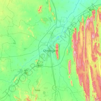
Nom : Carte topographique Chittorgarh, altitude, relief.
Altitude moyenne : 442 m
Altitude minimum : 371 m
Altitude maximum : 617 m
Faire un don
Équipez-vous pour votre prochaine aventure :
En tant que Partenaire Amazon, ce site perçoit une commission sur les achats éligibles sans surcoût pour vous.