
Faire un don
Équipez-vous pour votre prochaine aventure :
En tant que Partenaire Amazon, ce site perçoit une commission sur les achats éligibles sans surcoût pour vous.
Carte topographique Saint-Aubin
Cliquez sur la carte pour afficher l’altitude.
Faire un don
Équipez-vous pour votre prochaine aventure :
En tant que Partenaire Amazon, ce site perçoit une commission sur les achats éligibles sans surcoût pour vous.
Saint-Aubin
Le village chevauche sur les deux rives de l'Ardusson au fond d'un vallon dominé par des hauteurs dont les points culminants sont au nord-est la colline du Parc-De-Pont (209 m) et La Gloriette (160 m). Au sud-ouest, le relief apparaît pourtant moins accentué, la hauteur principale est marquée par la colline des Vignes dont l'altitude est à peu près la même que celle de la Gloriette.
Faire un don
Équipez-vous pour votre prochaine aventure :
En tant que Partenaire Amazon, ce site perçoit une commission sur les achats éligibles sans surcoût pour vous.
À propos de cette carte
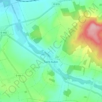
Nom : Carte topographique Saint-Aubin, altitude, relief.
Altitude moyenne : 102 m
Altitude minimum : 61 m
Altitude maximum : 210 m
Itinéraires Aube, randonnée, VTT, course à pied et activités de plein air
Faire un don
Équipez-vous pour votre prochaine aventure :
En tant que Partenaire Amazon, ce site perçoit une commission sur les achats éligibles sans surcoût pour vous.
Autres cartes topographiques
Cliquez sur une carte pour visualiser sa topographie, son altitude et son relief.
Troyes
France > Grand Est > Aube > Troyes
La superficie de la commune de Troyes est de 1 320 ha quand la superficie moyenne communale en France métropolitaine s'établit à 1 505,8 ha ; son altitude varie de 100 m, au niveau de la Seine à la limite entre Troyes et Barberey-Saint-Sulpice, à 126 m au sud-ouest, à la limite du territoire communal de…
Altitude moyenne : 151 m
Faire un don
Équipez-vous pour votre prochaine aventure :
En tant que Partenaire Amazon, ce site perçoit une commission sur les achats éligibles sans surcoût pour vous.
Faire un don
Équipez-vous pour votre prochaine aventure :
En tant que Partenaire Amazon, ce site perçoit une commission sur les achats éligibles sans surcoût pour vous.
Faire un don
Équipez-vous pour votre prochaine aventure :
En tant que Partenaire Amazon, ce site perçoit une commission sur les achats éligibles sans surcoût pour vous.
Faire un don
Équipez-vous pour votre prochaine aventure :
En tant que Partenaire Amazon, ce site perçoit une commission sur les achats éligibles sans surcoût pour vous.
Fontaine-Mâcon
France > Grand Est > Aube > Fontaine-Mâcon > Fontaine-Mâcon
Fontaine-Mâcon est une commune située dans le département de l'Aube (région de Champagne-Ardenne), à la limite avec l'Yonne et la Seine-et-Marne. La ville de Fontaine-Mâcon appartient au canton de Nogent-sur-Seine et à l'arrondissement de Nogent-sur-Seine. Les habitants de Fontaine-Mâcon s'appellent…
Altitude moyenne : 93 m
Faire un don
Équipez-vous pour votre prochaine aventure :
En tant que Partenaire Amazon, ce site perçoit une commission sur les achats éligibles sans surcoût pour vous.
Faire un don
Équipez-vous pour votre prochaine aventure :
En tant que Partenaire Amazon, ce site perçoit une commission sur les achats éligibles sans surcoût pour vous.
Faire un don
Équipez-vous pour votre prochaine aventure :
En tant que Partenaire Amazon, ce site perçoit une commission sur les achats éligibles sans surcoût pour vous.
Faire un don
Équipez-vous pour votre prochaine aventure :
En tant que Partenaire Amazon, ce site perçoit une commission sur les achats éligibles sans surcoût pour vous.
Faire un don
Équipez-vous pour votre prochaine aventure :
En tant que Partenaire Amazon, ce site perçoit une commission sur les achats éligibles sans surcoût pour vous.
Faire un don
Équipez-vous pour votre prochaine aventure :
En tant que Partenaire Amazon, ce site perçoit une commission sur les achats éligibles sans surcoût pour vous.
Faire un don
Équipez-vous pour votre prochaine aventure :
En tant que Partenaire Amazon, ce site perçoit une commission sur les achats éligibles sans surcoût pour vous.
Faire un don
Équipez-vous pour votre prochaine aventure :
En tant que Partenaire Amazon, ce site perçoit une commission sur les achats éligibles sans surcoût pour vous.
Faire un don
Équipez-vous pour votre prochaine aventure :
En tant que Partenaire Amazon, ce site perçoit une commission sur les achats éligibles sans surcoût pour vous.
Faire un don
Équipez-vous pour votre prochaine aventure :
En tant que Partenaire Amazon, ce site perçoit une commission sur les achats éligibles sans surcoût pour vous.
Faire un don
Équipez-vous pour votre prochaine aventure :
En tant que Partenaire Amazon, ce site perçoit une commission sur les achats éligibles sans surcoût pour vous.
Anse de Jolivet
France > Grand Est > Aube > Lusigny-sur-Barse > Les Hautes Bones
Altitude moyenne : 135 m
Faire un don
Équipez-vous pour votre prochaine aventure :
En tant que Partenaire Amazon, ce site perçoit une commission sur les achats éligibles sans surcoût pour vous.
Le Mineroy Chalois
France > Grand Est > Aube > Aix-Villemaur-Pâlis > Aix-en-Othe
Altitude moyenne : 216 m
Faire un don
Équipez-vous pour votre prochaine aventure :
En tant que Partenaire Amazon, ce site perçoit une commission sur les achats éligibles sans surcoût pour vous.
Faire un don
Équipez-vous pour votre prochaine aventure :
En tant que Partenaire Amazon, ce site perçoit une commission sur les achats éligibles sans surcoût pour vous.
Faire un don
Équipez-vous pour votre prochaine aventure :
En tant que Partenaire Amazon, ce site perçoit une commission sur les achats éligibles sans surcoût pour vous.
Faire un don
Équipez-vous pour votre prochaine aventure :
En tant que Partenaire Amazon, ce site perçoit une commission sur les achats éligibles sans surcoût pour vous.
Les Loges
France > Grand Est > Aube > Saint-Hilaire-sous-Romilly > La Noue des Rois
Altitude moyenne : 68 m
Faire un don
Équipez-vous pour votre prochaine aventure :
En tant que Partenaire Amazon, ce site perçoit une commission sur les achats éligibles sans surcoût pour vous.
Pont-sur-Seine
France > Grand Est > Aube > Pont-sur-Seine > Pont-sur-Seine
Située sur la rive gauche de la Seine, à une altitude de 71 m environ, la commune présente une superficie voisine de 16 km2.
Altitude moyenne : 78 m
Montfey
France > Grand Est > Aube > Montfey > Montfey
Le village où se trouve la mairie, se trouve au sommet d'un coteau, à 173 mètres d'altitude, d'où l'on a un vaste panorama sur la campagne environnante où alternent vastes champs, boqueteaux, vallons et coteaux boisés, hameaux. Il est traversé par la D 22, par la D 90 et par le sentier de randonnée «…
Altitude moyenne : 147 m
Faire un don
Équipez-vous pour votre prochaine aventure :
En tant que Partenaire Amazon, ce site perçoit une commission sur les achats éligibles sans surcoût pour vous.
Montceaux-lès-Vaudes
France > Grand Est > Aube > Montceaux-lès-Vaudes > Montceaux-lès-Vaudes
Altitude moyenne : 136 m
Saint-Benoist-sur-Vanne
France > Grand Est > Aube > Saint-Benoist-sur-Vanne > Saint-Benoist-sur-Vanne
Altitude moyenne : 158 m
Faire un don
Équipez-vous pour votre prochaine aventure :
En tant que Partenaire Amazon, ce site perçoit une commission sur les achats éligibles sans surcoût pour vous.
Ferreux-Quincey
France > Grand Est > Aube > Ferreux-Quincey > Ferreux-Quincey
Altitude moyenne : 119 m
Faire un don
Équipez-vous pour votre prochaine aventure :
En tant que Partenaire Amazon, ce site perçoit une commission sur les achats éligibles sans surcoût pour vous.
Pre aux Boeufs
France > Grand Est > Aube > Saint-Parres-aux-Tertres > Pre aux Boeufs
Altitude moyenne : 111 m
Beauvoir-sur-Sarce
France > Grand Est > Aube > Bragelogne > Beauvoir-sur-Sarce
Altitude moyenne : 263 m
Faire un don
Équipez-vous pour votre prochaine aventure :
En tant que Partenaire Amazon, ce site perçoit une commission sur les achats éligibles sans surcoût pour vous.