
Carte topographique Pedra Azul
Carte interactive
Cliquez sur la carte pour afficher l’altitude.
À propos de cette carte
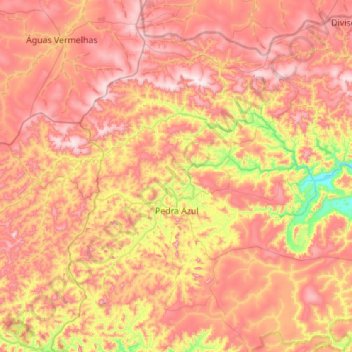
Nom : Carte topographique Pedra Azul, altitude, relief.
Altitude moyenne : 773 m
Altitude minimum : 418 m
Altitude maximum : 1 068 m
The city belongs to the mesoregion of Jequitinhonha and to the microregion of Pedra Azul. The elevation of the municipal seat is 617 meters. It became a municipality in 1911. This municipality is located 16 km. to the east of the important BR-116 highway, which links Rio de Janeiro to Salvador. The boundary with the state of Bahia is 49 km. to the northeast.