
Carte topographique Lolo National Forest
Carte interactive
Cliquez sur la carte pour afficher l’altitude.
À propos de cette carte
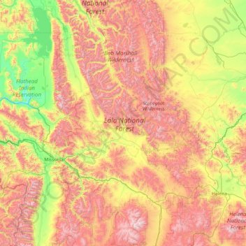
Nom : Carte topographique Lolo National Forest, altitude, relief.
Altitude moyenne : 1 564 m
Altitude minimum : 757 m
Altitude maximum : 2 983 m
Autres cartes topographiques
Cliquez sur une carte pour visualiser sa topographie, son altitude et son relief.
Beaverhead-Deerlodge National Forest
Beaverhead-Deerlodge National Forest, Gravelly Range Road, Madison County, Montana, USA
Altitude moyenne : 2 004 m
Fort Peck Lake
USA > Montana > Park Grove
Fort Peck Lake, MT 117, Park Grove, Valley County, Montana, 59248, USA
Altitude moyenne : 632 m
Going-to-the-Sun Mountain
Going-to-the-Sun Mountain, Glacier County, Montana, USA
Altitude moyenne : 2 109 m
Westside Reservoir Park
Westside Reservoir Park, Butte, Silver Bow County, Montana, 59703, USA
Altitude moyenne : 1 813 m
Cabinet Mountains Wilderness Area
Cabinet Mountains Wilderness Area, Sanders County, Montana, USA
Altitude moyenne : 1 247 m
Mission Mountains Tribal Wilderness
Mission Mountains Tribal Wilderness, McDonald Lake Road, Lake County, Montana, USA
Altitude moyenne : 1 383 m
Capital Hill
Capital Hill, Boulder, Jefferson County, Montana, 59632, USA
Altitude moyenne : 1 502 m
Wurtz Hill
USA > Montana > Wurtz Hill
Wurtz Hill, Flathead County, Montana, USA
Altitude moyenne : 1 196 m
East Helena
USA > Montana > East Helena
East Helena, Lewis and Clark County, Montana, USA
Altitude moyenne : 1 187 m
Margaret Lake
Margaret Lake, Mokowanis Lake, Glacier County, Montana, USA
Altitude moyenne : 1 983 m
Mahtotopa Mountain
Mahtotopa Mountain, Glacier County, Montana, USA
Altitude moyenne : 2 148 m
Gem Glacier
Gem Glacier, Highline Trail, Flathead County, Montana, USA
Altitude moyenne : 2 150 m
Cloudcroft Peaks
Cloudcroft Peaks, Flathead County, Montana, USA
Altitude moyenne : 2 034 m
Fairy Lake
Fairy Lake, Fairy Lake Access Trail, Gallatin County, Montana, USA
Altitude moyenne : 2 445 m
Haugan Mountain
Haugan Mountain, Mineral County, Montana, 59867, USA
Altitude moyenne : 1 207 m
Wahcheechee Mountain
Wahcheechee Mountain, Glacier County, Montana, USA
Altitude moyenne : 2 133 m
North Swiftcurrent Glacier
North Swiftcurrent Glacier, Swiftcurrent Lookout Trail, Flathead County, Montana, USA
Altitude moyenne : 2 051 m
Wolftail Mountain
Wolftail Mountain, Flathead County, Montana, USA
Altitude moyenne : 2 042 m
Kupunkamint Mountain
Kupunkamint Mountain, Glacier County, Montana, USA
Altitude moyenne : 2 262 m
Lewis and Clark National Forest
Lewis and Clark National Forest, Moose Creek Road, Meagher County, Montana, USA
Altitude moyenne : 1 338 m
Curly Bear Mountain
Curly Bear Mountain, Pondera County, Montana, USA
Altitude moyenne : 2 008 m
Brave Dog Mountain
Brave Dog Mountain, Flathead County, Montana, USA
Altitude moyenne : 2 072 m
Mad Wolf Mountain
Mad Wolf Mountain, Glacier County, Montana, USA
Altitude moyenne : 2 177 m
Beartooth Glacier
Beartooth Glacier, Carbon County, Montana, USA
Altitude moyenne : 3 240 m
Upper Missouri River Breaks National Monument
Upper Missouri River Breaks National Monument, Fergus County, Montana, USA
Altitude moyenne : 1 003 m
Grasshopper Glacier
Grasshopper Glacier, Carbon County, Montana, USA
Altitude moyenne : 3 407 m
Fusillade Mountain
Fusillade Mountain, Glacier County, Montana, USA
Altitude moyenne : 2 022 m
Devils Slide
Devils Slide, Many Glacier Road, Babb, Glacier County, Montana, 59411, USA
Altitude moyenne : 1 502 m
Nemesis Mountain
Nemesis Mountain, Beaverhead County, Montana, USA
Altitude moyenne : 2 426 m
Scapegoat Wilderness Area
Scapegoat Wilderness Area, Lewis and Clark County, Montana, USA
Altitude moyenne : 1 918 m