
Carte topographique Gemeinde Kössen
Carte interactive
Cliquez sur la carte pour afficher l’altitude.
À propos de cette carte
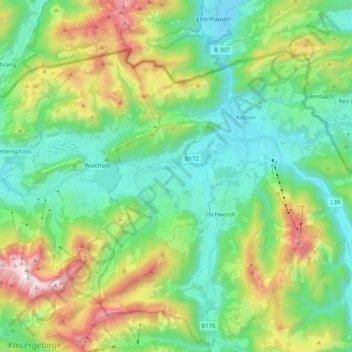
Nom : Carte topographique Gemeinde Kössen, altitude, relief.
Lieu : Gemeinde Kössen, Bezirk Kitzbühel, Tyrol, 6345, Austria (47.59728 12.31908 47.69638 12.52534)
Altitude moyenne : 979 m
Altitude minimum : 562 m
Altitude maximum : 1 977 m
Kössen's topography lends itself to air sports in the summer months. The surrounding mountain massifs create great thermals, which are near-perfect for hang gliding and paragliding flights, whilst the valley-floor makes safe landing-grounds, as it is broad, flat and mostly meadow-land; furthermore, the winter ski-lifts allow equal access to the summits in their off-season, for the new market of air-sports adventurers.
Autres cartes topographiques
Cliquez sur une carte pour visualiser sa topographie, son altitude et son relief.
Scheffau
Austria > Bezirk Kitzbühel > Sankt Johann in Tirol
Scheffau, Sankt Johann in Tirol, Bezirk Kitzbühel, Austria
Altitude moyenne : 939 m
Mittagskogel
Austria > Bezirk Kitzbühel > Jochberg
Mittagskogel, Jochberg, Bezirk Kitzbühel, Austria
Altitude moyenne : 1 838 m
Kitzbühel
Kitzbühel, Bezirk Kitzbühel, 6370, Austria
Altitude moyenne : 1 176 m