
Carte topographique Arkhyz
Carte interactive
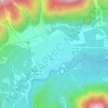
Cliquez sur la carte pour afficher l’altitude.
À propos de cette carte
Nom : Carte topographique Arkhyz, altitude, relief.
Altitude moyenne : 1 547 m
Altitude minimum : 1 427 m
Altitude maximum : 1 937 m
Arkhyz (also Nizhny Arkhyz Russian: Архыз; Karachay-Balkar: Ырхыз, Irxız; "mudflows") is a village in the valley of the Bolshoy Zelenchuk River, in the Republic of Karachay–Cherkessia, Greater Caucasus, Russia, about 70 km inland from the Black Sea shore. The modern village was founded in 1923 near the confluence of the Arkhyz and Pshish rivers. It is located in a mountainous region in the vicinity of the eponymous aul sitting at an altitude of 1,450 meters. The elevation of the surrounding mountains is more than 3,000 meters above the sea. The population is 505 (2010 Census).
Autres cartes topographiques
Cliquez sur une carte pour visualiser sa topographie, son altitude et son relief.
Архыз
Russia > Karachay-Cherkessia > Zelenchuksky District
Архыз, Архызское сельское поселение, Zelenchuksky District, Karachay-Cherkessia, North Caucasian Federal District, Russia
Altitude moyenne : 2 345 m