
Carte topographique Parque Nacional Natural Los Nevados
Carte interactive
Cliquez sur la carte pour afficher l’altitude.
À propos de cette carte
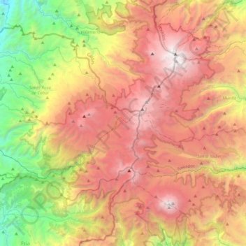
Nom : Carte topographique Parque Nacional Natural Los Nevados, altitude, relief.
Altitude moyenne : 3 355 m
Altitude minimum : 1 461 m
Altitude maximum : 5 286 m
At the end of the 19th century, six glaciers existed on the peaks of El Ruiz, Santa Isabel, Tolima, El Cisne, Quindío and the current Paramillo de Santa Rosa, and were located at an altitude of 4500 meters above sea level.