
Faire un don
Équipez-vous pour votre prochaine aventure :
En tant que Partenaire Amazon, ce site perçoit une commission sur les achats éligibles sans surcoût pour vous.
Carte topographique Begun
Cliquez sur la carte pour afficher l’altitude.
Faire un don
Équipez-vous pour votre prochaine aventure :
En tant que Partenaire Amazon, ce site perçoit une commission sur les achats éligibles sans surcoût pour vous.
Begun
Begun is located at 24°59′N 75°00′E / 24.98°N 75.0°E / 24.98; 75.0. It has an average elevation of 412 metres (1351 feet). Begun has very good soil for agriculture. In Begun Tehsil there are two famous places: Jogania Mata and Menal. Jogania Mata Temple is situated at the top of the mountains. It is 20 km from Begun. Jogania Mata Temple is a famous in the Chittorgarh district. Menal is near Jogania Mata. It is 25 km from Begun. Begun is a good tourist place and a very good fort situated nearby named as Nahargarh.
Faire un don
Équipez-vous pour votre prochaine aventure :
En tant que Partenaire Amazon, ce site perçoit une commission sur les achats éligibles sans surcoût pour vous.
À propos de cette carte
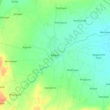
Nom : Carte topographique Begun, altitude, relief.
Altitude moyenne : 422 m
Altitude minimum : 407 m
Altitude maximum : 452 m
Faire un don
Équipez-vous pour votre prochaine aventure :
En tant que Partenaire Amazon, ce site perçoit une commission sur les achats éligibles sans surcoût pour vous.