
Carte topographique Zile
Carte interactive
Cliquez sur la carte pour afficher l’altitude.
Zile
Zile covers an area of 1,512 square kilometres (584 sq mi) within its city limits and has an elevation of 710 metres (2,330 ft). Turhal, Çekerek, Artova, Kadışehri, and Amasya are all towns located near Zile. The city is mostly surrounded by a fertile plain called Zile Ovası crossed by the Yeşil River and can produce harvests twice a year. South of the city, however, are the Deveci Mountains (1,892 m / 6,207 ft high), Güvercin Çalı, and Hüseyin Gazi Hill. Zile once had a great forest covering most of the plain, but during the 1950s, the city lost much of its forest because of the excessive breeding of goats and the use of wood for heating purposes. However, there is a recent study to plan reforestation in the area.
À propos de cette carte
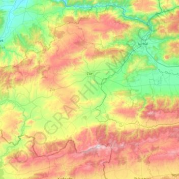
Nom : Carte topographique Zile, altitude, relief.
Lieu : Zile, Tokat, Black Sea Region, 60400, Turkey (40.05922 35.43958 40.44936 36.11907)
Altitude moyenne : 985 m
Altitude minimum : 423 m
Altitude maximum : 1 897 m
Autres cartes topographiques
Cliquez sur une carte pour visualiser sa topographie, son altitude et son relief.