
Carte topographique Boundary Peak
Carte interactive
Cliquez sur la carte pour afficher l’altitude.
À propos de cette carte
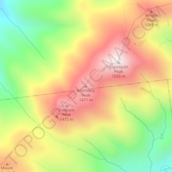
Nom : Carte topographique Boundary Peak, altitude, relief.
Lieu : Boundary Peak, Essex County, New York, USA (44.13980 -73.99390 44.13990 -73.99380)
Altitude moyenne : 1 175 m
Altitude minimum : 772 m
Altitude maximum : 1 548 m
Autres cartes topographiques
Cliquez sur une carte pour visualiser sa topographie, son altitude et son relief.
Bramanville
USA > New York > Bramanville
Bramanville, Town of Cobleskill, Schoharie County, New York, 12092, USA
Altitude moyenne : 320 m
Little Britain
USA > New York > Little Britain
Little Britain, Town of New Windsor, Orange County, New York, 12575, USA
Altitude moyenne : 140 m
Avalanche Lake
Avalanche Lake, Avalanche Pass Trail, Essex County, New York, USA
Altitude moyenne : 1 066 m
Mount Warren
Mount Warren, Town of Bovina, Delaware County, New York, USA
Altitude moyenne : 677 m
New Windsor
USA > New York > New Windsor
New Windsor, Town of New Windsor, Orange County, New York, USA
Altitude moyenne : 39 m
Sawtooth Mountains
Sawtooth Mountains, Franklin County, New York, USA
Altitude moyenne : 927 m
Big Bear Mountain
Big Bear Mountain, Town of Johnsburg, Warren County, New York, USA
Altitude moyenne : 616 m
Chinatown
USA > New York > New York City
Chinatown, Manhattan, Manhattan Community Board 2, New York County, New York City, New York, USA
Altitude moyenne : 12 m
Roosevelt Island
USA > New York > New York City
Roosevelt Island, Manhattan Community Board 8, New York County, New York City, New York, 10044, USA
Altitude moyenne : 13 m
Livingston Island
Livingston Island, Town of Philipstown, Putnam County, New York, 10922, USA
Altitude moyenne : 156 m
Flat Top Mountain
Flat Top Mountain, Franklin County, New York, USA
Altitude moyenne : 568 m