
Carte topographique Los Katíos National Park
Carte interactive
Cliquez sur la carte pour afficher l’altitude.
À propos de cette carte
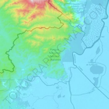
Nom : Carte topographique Los Katíos National Park, altitude, relief.
Lieu : Los Katíos National Park, Urabá, Chocó, RAP Pacífico, Colombia (7.67867 -77.39808 7.96955 -77.00584)
Altitude moyenne : 146 m
Altitude minimum : -2 m
Altitude maximum : 1 354 m
Los Katíos National Natural Park (Spanish: Parque Nacional Natural (PNN) Los Katíos) is a protected area located in northwest Colombia which covers about 720 km2 (280 sq mi). The elevation ranges between 50 and 600 m (160 and 1,970 ft). It is a part of the Darién Gap, a densely forested area shared by Panama and Colombia, and is contiguous with the Darién National Park in Panama. The Pan-American Highway, when completed as proposed, would pass near or through Los Katíos. The park was declared a UNESCO World Heritage Site in 1994 due to the extraordinary diversity of plant and animal species represented.
Autres cartes topographiques
Cliquez sur une carte pour visualiser sa topographie, son altitude et son relief.
Pizarro
Colombia > Chocó > Bajo Baudó (Pizarro)
Pizarro, Bajo Baudó (Pizarro), Pacífico Sur, Chocó, Colombia
Altitude moyenne : 15 m
Bahía Solano (Mutis)
Bahía Solano (Mutis), Pacífico Norte, Chocó, RAP Pacífico, Colombia
Altitude moyenne : 130 m
Docordó
Colombia > Chocó > El Litoral del San Juan
Docordó, El Litoral del San Juan, Pacífico Sur, Chocó, Colombia
Altitude moyenne : 7 m
Huaca
Colombia > Chocó > Bahía Solano (Mutis)
Huaca, Bahía Solano (Mutis), Pacífico Norte, Chocó, Colombia
Altitude moyenne : 47 m