
Carte topographique Leavenworth
Carte interactive
Cliquez sur la carte pour afficher l’altitude.
À propos de cette carte
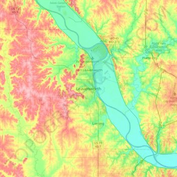
Nom : Carte topographique Leavenworth, altitude, relief.
Altitude moyenne : 277 m
Altitude minimum : 223 m
Altitude maximum : 347 m
Leavenworth is located at 39°18′40″N 94°55′21″W / 39.31111°N 94.92250°W / 39.31111; -94.92250 (39.3111112, −94.9224637) at an elevation of 840 feet (256 m).[5] Located in northeastern Kansas at the junction of U.S. Route 73 and Kansas Highway 92 (K-92), Leavenworth is 25 mi (40 km) northwest of downtown Kansas City, 145 mi (233 km) south-southeast of Omaha, and 165 mi (266 km) northeast of Wichita.[18][19]