
Carte topographique Millwood
Carte interactive
Cliquez sur la carte pour afficher l’altitude.
À propos de cette carte
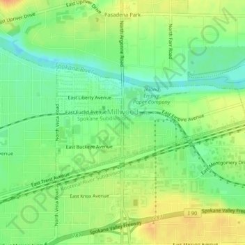
Nom : Carte topographique Millwood, altitude, relief.
Lieu : Millwood, Spokane County, Washington, United States (47.67891 -117.29348 47.69092 -117.26233)
Altitude moyenne : 600 m
Altitude minimum : 582 m
Altitude maximum : 619 m
The topography of the city is mostly flat as it lies on the floor of the Spokane Valley, though it does slope gently down towards the north. The northern edge of town is defined by the Spokane River, where the terrain promptly drops about 20 feet down to the river bank.
Autres cartes topographiques
Cliquez sur une carte pour visualiser sa topographie, son altitude et son relief.
Spokane
United States > Washington > Spokane County
Spokane, Spokane County, Washington, United States
Altitude moyenne : 655 m
Newman Lake
United States > Washington > Spokane County
Newman Lake, Spokane County, Washington, 99025, United States
Altitude moyenne : 661 m
Hog Lake
United States > Washington > Spokane County
Hog Lake, Spokane County, Washington, United States
Altitude moyenne : 664 m
Silver Lake
United States > Washington > Spokane County
Silver Lake, Spokane County, Washington, 99022, United States
Altitude moyenne : 741 m
Mead
United States > Washington > Spokane County
Mead, Spokane County, Washington, 99021, United States
Altitude moyenne : 585 m
Country Homes
United States > Washington > Spokane County
Country Homes, Spokane County, Washington, 99251, United States
Altitude moyenne : 599 m
Airway Heights
United States > Washington > Spokane County
Airway Heights, Spokane County, Washington, 99001, United States
Altitude moyenne : 724 m
Cheney
United States > Washington > Spokane County
Cheney, Spokane County, Washington, United States
Altitude moyenne : 728 m
Deer Park
United States > Washington > Spokane County
Deer Park, Spokane County, Washington, 99006, United States
Altitude moyenne : 658 m
Mount Spokane
United States > Washington > Spokane County
Mount Spokane, Spokane County, Washington, United States
Altitude moyenne : 1 475 m
Spokane Valley
United States > Washington > Spokane County
Spokane Valley, Spokane County, Washington, United States
Altitude moyenne : 673 m
Liberty Lake
United States > Washington > Spokane County
Liberty Lake, Spokane County, Washington, 99019, United States
Altitude moyenne : 644 m
Nine Mile Falls
United States > Washington > Spokane County
Nine Mile Falls, Spokane County, Washington, 99026, United States
Altitude moyenne : 536 m
Riverside State Park
United States > Washington > Spokane County > Spokane
Riverside State Park, Spokane, Spokane County, Washington, United States
Altitude moyenne : 645 m
Medical Lake
United States > Washington > Spokane County
Medical Lake, Spokane County, Washington, 99022, United States
Altitude moyenne : 738 m
Medical Lake
United States > Washington > Spokane County > Medical Lake > Medical Lake
Medical Lake, Spokane County, Washington, 99022, United States
Altitude moyenne : 747 m
Chattaroy
United States > Washington > Spokane County > Chattaroy
Chattaroy, Spokane County, Washington, 99005, United States
Altitude moyenne : 559 m