Géolocaliser

Carte topographique Hachum

Cliquez sur la carte pour afficher l’altitude.

À propos de cette carte

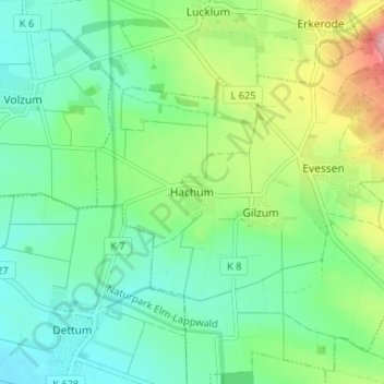
Nom : Carte topographique Hachum, altitude, relief.

Lieu : Hachum, Evessen, Samtgemeinde Sickte, Landkreis Wolfenbüttel, Lower Saxony, 38173, Germany (52.16618 10.66650 52.20618 10.70650)

Altitude moyenne : 127 m

Altitude minimum : 87 m

Altitude maximum : 222 m

Autres cartes topographiques

Cliquez sur une carte pour visualiser sa topographie, son altitude et son relief.

Berel

Germany > Lower Saxony > Landkreis Wolfenbüttel

Altitude moyenne : 121 m

Erkerode

Germany > Lower Saxony > Landkreis Wolfenbüttel

Altitude moyenne : 178 m

Wolfenbüttel

Germany > Lower Saxony > Landkreis Wolfenbüttel

The town center is located at an elevation of 77 ft (23 m) on the Oker river near the confluence with its Altenau tributary, about 13 km (8.1 mi) south of Brunswick and 60 km (37 mi) southeast of the state capital Hannover. Wolfenbüttel is situated about half-way between the Harz mountain range in the south…

Altitude moyenne : 99 m

Veltheim

Germany > Lower Saxony > Landkreis Wolfenbüttel

Altitude moyenne : 132 m

Équipez-vous pour votre prochaine aventure :

📦Boîtes étanches outdoor - Protection du matériel sensible
📦Boîtier Étanche de Protection - Sécurité pour clés, argent et petits objets sensibles
📏Altimètres & baromètres - Instruments pour surveiller altitude et météo
🪢Corde Paracorde - Corde de survie ultra-résistante pour usages multiples
🩹Kit de Premiers Secours - Trousse compacte avec pansements, désinfectant et couverture survie

En tant que Partenaire Amazon, ce site perçoit une commission sur les achats éligibles sans surcoût pour vous.