
Carte topographique Zemplín
Carte interactive
Cliquez sur la carte pour afficher l’altitude.
À propos de cette carte
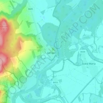
Nom : Carte topographique Zemplín, altitude, relief.
Altitude moyenne : 116 m
Altitude minimum : 87 m
Altitude maximum : 242 m
The village lies at an altitude of 106 metres and covers an area of 14,67 km². It is located near the junction point of the rivers Ondava and Latorica (tributaries of the river Bodrog) in eastern Slovakia.
Autres cartes topographiques
Cliquez sur une carte pour visualiser sa topographie, son altitude et son relief.
Borša
Slovakia > Region of Košice > District of Trebišov
Borša, District of Trebišov, Region of Košice, Eastern Slovakia, 076 32, Slovakia
Altitude moyenne : 114 m
Kysta
Slovakia > Region of Košice > District of Trebišov
Kysta, District of Trebišov, Region of Košice, Eastern Slovakia, Slovakia
Altitude moyenne : 177 m
Boťany
Slovakia > Region of Košice > District of Trebišov
Boťany, District of Trebišov, Region of Košice, Eastern Slovakia, 076 43, Slovakia
Altitude moyenne : 101 m
Borša
Slovakia > Region of Košice > District of Trebišov > Borša > Borša
Borša, District of Trebišov, Region of Košice, Eastern Slovakia, 076 32, Slovakia
Altitude moyenne : 110 m