
Carte topographique Area F (Cowichan Lake South / Skutz Falls)
Carte interactive
Cliquez sur la carte pour afficher l’altitude.
À propos de cette carte
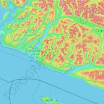
Nom : Carte topographique Area F (Cowichan Lake South / Skutz Falls), altitude, relief.
Altitude moyenne : 273 m
Altitude minimum : -3 m
Altitude maximum : 1 518 m
Autres cartes topographiques
Cliquez sur une carte pour visualiser sa topographie, son altitude et son relief.
Duncan
Canada > British Columbia > Cowichan Valley Regional District > Duncan > Duncan
Duncan, Cowichan Valley Regional District, British Columbia, V9L 1W3, Canada
Altitude moyenne : 48 m
Lake Cowichan
Canada > British Columbia > Cowichan Valley Regional District
Lake Cowichan, Cowichan Valley Regional District, British Columbia, V0R 2G0, Canada
Altitude moyenne : 378 m