
Carte topographique Iturup
Carte interactive
Cliquez sur la carte pour afficher l’altitude.
À propos de cette carte
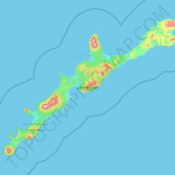
Nom : Carte topographique Iturup, altitude, relief.
Altitude moyenne : 31 m
Altitude minimum : 0 m
Altitude maximum : 1 605 m
The deposits of the Vetrovoy Isthmus include volcanic-tectonic dislocations, pumice pyroclastics, aeolian-ash deposits and soil-tephra formations. The morphometric parameters of the basement terrace indicate an area elevation rate during the last phase of coastal marine accumulation that could reach 4 mm/year, slightly higher than the 3.5 m/year recorded during the last 6000 thousand years.