
Carte topographique Apple Valley
Carte interactive
Cliquez sur la carte pour afficher l’altitude.
À propos de cette carte
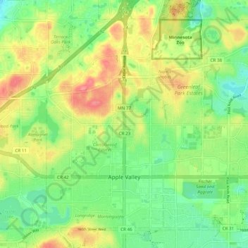
Nom : Carte topographique Apple Valley, altitude, relief.
Lieu : Apple Valley, Dakota County, Minnesota, 55124, United States (44.71734 -93.24835 44.77589 -93.15134)
Altitude moyenne : 301 m
Altitude minimum : 270 m
Altitude maximum : 343 m
According to the United States Census Bureau, the city has a total area of 17.57 square miles (45.51 km2), of which 16.86 square miles (43.67 km2) is land and 0.71 square miles (1.84 km2) is water. The city's geography is rolling, with elevation from the lowest to the highest points in the city varying by one hundred feet (thirty metres) or more. The downtown area and its adjacent residential district (which formed the original core of the city when it was incorporated) are in a shallow valley.
Autres cartes topographiques
Cliquez sur une carte pour visualiser sa topographie, son altitude et son relief.
Lakeville
United States > Minnesota > Dakota County
Lakeville, Dakota County, Minnesota, 55044, United States
Altitude moyenne : 305 m
Eagan
United States > Minnesota > Dakota County
Eagan, Dakota County, Minnesota, United States
Altitude moyenne : 267 m
Hastings
United States > Minnesota > Dakota County > Hastings > Hastings
Hastings, Dakota County, Minnesota, 55033, United States
Altitude moyenne : 243 m
Burnsville
United States > Minnesota > Dakota County > Burnsville
Burnsville, Dakota County, Minnesota, United States
Altitude moyenne : 271 m
Rosemount
United States > Minnesota > Dakota County > Rosemount
Rosemount, Dakota County, Minnesota, 55068, United States
Altitude moyenne : 287 m
Farmington
United States > Minnesota > Dakota County
Farmington, Dakota County, Minnesota, 55024, United States
Altitude moyenne : 280 m