
Carte topographique Spytkowice
Carte interactive
Cliquez sur la carte pour afficher l’altitude.
À propos de cette carte
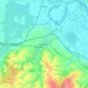
Nom : Carte topographique Spytkowice, altitude, relief.
Altitude moyenne : 241 m
Altitude minimum : 213 m
Altitude maximum : 331 m
Autres cartes topographiques
Cliquez sur une carte pour visualiser sa topographie, son altitude et son relief.
Andrychów
Poland > Lesser Poland Voivodeship > Wadowice County
Andrychów, gmina Andrychów, Wadowice County, Lesser Poland Voivodeship, 34-120, Poland
Altitude moyenne : 347 m
Radocza
Poland > Lesser Poland Voivodeship > Wadowice County > Radocza
Radocza, gmina Tomice, Wadowice County, Lesser Poland Voivodeship, Poland
Altitude moyenne : 274 m