
Faire un don
Équipez-vous pour votre prochaine aventure :
En tant que Partenaire Amazon, ce site perçoit une commission sur les achats éligibles sans surcoût pour vous.
Carte topographique Huangshi
Cliquez sur la carte pour afficher l’altitude.
Faire un don
Équipez-vous pour votre prochaine aventure :
En tant que Partenaire Amazon, ce site perçoit une commission sur les achats éligibles sans surcoût pour vous.
Huangshi
Huangshi is located in southeastern Hubei province, primarily along the southwestern bank of one of the major bends in the Yangtze River. It is located 100 kilometers (62 mi) southeast of Wuhan, and borders Jiangxi province to the south. Its area was reported by the local government as 4,583 square kilometers (1,770 sq mi); elsewhere, the number of 4,630 square kilometers (1,790 sq mi) was given. The terrain is mostly small mountains and hills. The tallest mountain is 7 Summit Mountain with an elevation of 860 meters (2,820 ft) above sea level. Huangshi is also located in a major lake district between Hunan's Dongting Lake and Jiangxi's Poyang lake and has dozens of large lakes. Huangshi's climate is sub-temperate. Average annual temperature is 17 °C (63 °F) and precipitation is 1,400 mm (55.1 in). There are 264 frost free days. It is possible to see limited snowfall between December and February.
Faire un don
Équipez-vous pour votre prochaine aventure :
En tant que Partenaire Amazon, ce site perçoit une commission sur les achats éligibles sans surcoût pour vous.
À propos de cette carte
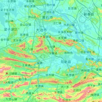
Nom : Carte topographique Huangshi, altitude, relief.
Lieu : Huangshi, Hubei, China (29.50855 114.52622 30.32826 115.50517)
Altitude moyenne : 123 m
Altitude minimum : 8 m
Altitude maximum : 924 m
Faire un don
Équipez-vous pour votre prochaine aventure :
En tant que Partenaire Amazon, ce site perçoit une commission sur les achats éligibles sans surcoût pour vous.