
Carte topographique Coldcut
Carte interactive
Cliquez sur la carte pour afficher l’altitude.
À propos de cette carte
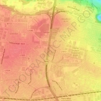
Nom : Carte topographique Coldcut, altitude, relief.
Altitude moyenne : 56 m
Altitude minimum : 8 m
Altitude maximum : 70 m
Autres cartes topographiques
Cliquez sur une carte pour visualiser sa topographie, son altitude et son relief.
Palmerstown Village ED
Palmerstown Village ED, Dublin 20, South Dublin, County Dublin, Leinster, Ireland
Altitude moyenne : 50 m
Redcowfarm
Redcowfarm, Palmerstown Village ED, Dublin 20, South Dublin, County Dublin, Leinster, Ireland
Altitude moyenne : 45 m