
Carte topographique Dobl
Carte interactive
Cliquez sur la carte pour afficher l’altitude.
À propos de cette carte
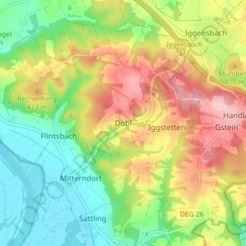
Nom : Carte topographique Dobl, altitude, relief.
Lieu : Dobl, Winzer, Landkreis Deggendorf, Bavaria, 94547, Germany (48.69626 13.10065 48.73626 13.14065)
Altitude moyenne : 378 m
Altitude minimum : 303 m
Altitude maximum : 476 m
Autres cartes topographiques
Cliquez sur une carte pour visualiser sa topographie, son altitude et son relief.
Mahd
Germany > Bavaria > Landkreis Deggendorf > Osterhofen > Arbing
Mahd, Arbing, Osterhofen, Landkreis Deggendorf, Bavaria, 94550, Germany
Altitude moyenne : 311 m
Deggendorf
Germany > Bavaria > Landkreis Deggendorf
Deggendorf, Landkreis Deggendorf, Bavaria, 94469, Germany
Altitude moyenne : 449 m
Neuhausen
Germany > Bavaria > Landkreis Deggendorf
Neuhausen, Offenberg, Landkreis Deggendorf, Bavaria, 94560, Germany
Altitude moyenne : 341 m
Otzing
Germany > Bavaria > Landkreis Deggendorf
Otzing, Oberpöring (VGem), Landkreis Deggendorf, Bavaria, 94563, Germany
Altitude moyenne : 328 m
Schuhreith
Germany > Bavaria > Landkreis Deggendorf > Mimming
Schuhreith, Mimming, Hengersberg, Landkreis Deggendorf, Bavaria, 94491, Germany
Altitude moyenne : 337 m
Plattling
Germany > Bavaria > Landkreis Deggendorf
Plattling, Landkreis Deggendorf, Bavaria, 94447, Germany
Altitude moyenne : 321 m