
Carte topographique Concrete
Carte interactive
Cliquez sur la carte pour afficher l’altitude.
À propos de cette carte
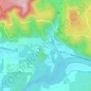
Nom : Carte topographique Concrete, altitude, relief.
Lieu : Concrete, Skagit County, Washington, United States (48.52557 -121.76615 48.55053 -121.73227)
Altitude moyenne : 125 m
Altitude minimum : 42 m
Altitude maximum : 341 m
Mears Field (3W5), formerly known as Concrete Municipal Airport, is located one mile south of Concrete at an elevation of 267 ft MSL.
Autres cartes topographiques
Cliquez sur une carte pour visualiser sa topographie, son altitude et son relief.
Mount Erie
United States > Washington > Skagit County > Anacortes
Mount Erie, Anacortes, Skagit County, Washington, 98221, United States
Altitude moyenne : 128 m
Marblemount
United States > Washington > Skagit County
Marblemount, Skagit County, Washington, United States
Altitude moyenne : 249 m
Big Lake
United States > Washington > Skagit County
Big Lake, Skagit County, Washington, 98274, United States
Altitude moyenne : 80 m
Anacortes
United States > Washington > Skagit County
Anacortes, Skagit County, Washington, 98221, United States
Altitude moyenne : 36 m
Anacortes
United States > Washington > Skagit County > Anacortes > Anacortes
Anacortes, Skagit County, Washington, 98221, United States
Altitude moyenne : 37 m
Coal Mountain
United States > Washington > Skagit County
Coal Mountain, Skagit County, Washington, United States
Altitude moyenne : 1 003 m
Sedro-Woolley
United States > Washington > Skagit County
Sedro-Woolley, Skagit County, Washington, United States
Altitude moyenne : 28 m
Burlington
United States > Washington > Skagit County
Burlington, Skagit County, Washington, 98233, United States
Altitude moyenne : 12 m
Mount Vernon
United States > Washington > Skagit County
Mount Vernon, Skagit County, Washington, 98273, United States
Altitude moyenne : 37 m