
Carte topographique Nwoya
Carte interactive
Cliquez sur la carte pour afficher l’altitude.
Nwoya
The coordinates of the town are 2°38'06.0"N, 32°00'00.0"E (Latitude:2.6350; Longitude:32.0000). Nwoya Town lies at an average elevation of 990 metres (3,250 ft) above sea level.
À propos de cette carte
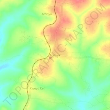
Nom : Carte topographique Nwoya, altitude, relief.
Lieu : Nwoya, Northern Region, Uganda (2.61370 31.98046 2.65370 32.02046)
Altitude moyenne : 1 004 m
Altitude minimum : 970 m
Altitude maximum : 1 040 m