
Carte topographique Beechworth
Carte interactive
Cliquez sur la carte pour afficher l’altitude.
À propos de cette carte
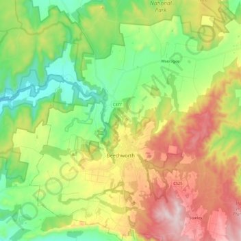
Nom : Carte topographique Beechworth, altitude, relief.
Lieu : Beechworth, Shire of Indigo, Victoria, 3747, Australia (-36.42161 146.55797 -36.24622 146.76198)
Altitude moyenne : 484 m
Altitude minimum : 218 m
Altitude maximum : 894 m
Autres cartes topographiques
Cliquez sur une carte pour visualiser sa topographie, son altitude et son relief.
Mount Pilot
Australia > Victoria > Beechworth
Mount Pilot, Beechworth, Shire of Indigo, Victoria, Australia
Altitude moyenne : 398 m
Beechworth
Australia > Victoria > Beechworth
Beechworth, Shire of Indigo, Hume, Victoria, 3747, Australia
Altitude moyenne : 533 m