
Carte topographique Town of Shelburne
Carte interactive
Cliquez sur la carte pour afficher l’altitude.
À propos de cette carte
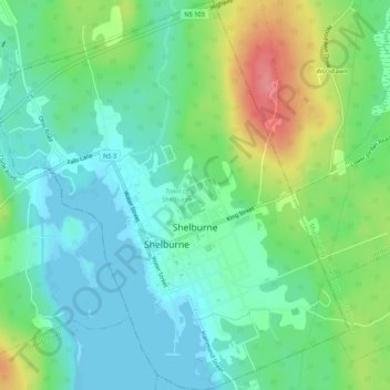
Nom : Carte topographique Town of Shelburne, altitude, relief.
Lieu : Town of Shelburne, Shelburne County, Nova Scotia, Canada (43.74952 -65.34439 43.78805 -65.29645)
Altitude moyenne : 28 m
Altitude minimum : -1 m
Altitude maximum : 91 m
Autres cartes topographiques
Cliquez sur une carte pour visualiser sa topographie, son altitude et son relief.
Granite Village
Canada > Nova Scotia > Shelburne County
Granite Village, Municipality of the District of Shelburne, Shelburne County, Nova Scotia, B0T 1J0, Canada
Altitude moyenne : 35 m
Rockland
Canada > Nova Scotia > Shelburne County
Rockland, Municipality of the District of Shelburne, Shelburne County, Nova Scotia, B0T 1V0, Canada
Altitude moyenne : 12 m
Arnold
Canada > Nova Scotia > Shelburne County > Little Harbour
Arnold, Little Harbour, Municipality of the District of Shelburne, Shelburne County, Nova Scotia, B0T 1V0, Canada
Altitude moyenne : 2 m
Stoney Island
Canada > Nova Scotia > Shelburne County
Stoney Island, Municipality of the District of Barrington, Shelburne County, Nova Scotia, B0W 1P0, Canada
Altitude moyenne : 3 m
Upper Port La Tour
Canada > Nova Scotia > Shelburne County
Upper Port La Tour, Municipality of the District of Barrington, Shelburne County, Nova Scotia, B0W 3N0, Canada
Altitude moyenne : 5 m
Lockeport
Canada > Nova Scotia > Shelburne County
Lockeport, Shelburne County, Nova Scotia, B0T 1L0, Canada
Altitude moyenne : 7 m
Louis Head
Canada > Nova Scotia > Shelburne County
Louis Head, Municipality of the District of Shelburne, Shelburne County, Nova Scotia, Canada
Altitude moyenne : 7 m
Locke Island
Canada > Nova Scotia > Shelburne County > Lockeport
Locke Island, Lockeport, Shelburne County, Nova Scotia, B0T 1L0, Canada
Altitude moyenne : 2 m
Sable River
Canada > Nova Scotia > Shelburne County
Sable River, Municipality of the District of Shelburne, Shelburne County, Nova Scotia, B0T 1J0, Canada
Altitude moyenne : 50 m
East Side of Ragged Island
Canada > Nova Scotia > Shelburne County
East Side of Ragged Island, Municipality of the District of Shelburne, Shelburne County, Nova Scotia, B0T 1V0, Canada
Altitude moyenne : 1 m
Ingomar
Canada > Nova Scotia > Shelburne County
Ingomar, Municipality of the District of Shelburne, Shelburne County, Nova Scotia, B0T 1W0, Canada
Altitude moyenne : 5 m
East Sable River
Canada > Nova Scotia > Shelburne County
East Sable River, Municipality of the District of Shelburne, Shelburne County, Nova Scotia, B0T 1V0, Canada
Altitude moyenne : 17 m
Lower Ohio
Canada > Nova Scotia > Shelburne County > Lower Ohio
Lower Ohio, Municipality of the District of Shelburne, Shelburne County, Nova Scotia, B0T 1W0, Canada
Altitude moyenne : 53 m
South Side
Canada > Nova Scotia > Shelburne County
South Side, Municipality of the District of Barrington, Shelburne County, Nova Scotia, B0W 1P0, Canada
Altitude moyenne : 3 m