
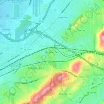
Carte topographique Oak Ridge Park
Carte interactive
Cliquez sur la carte pour afficher l’altitude.
À propos de cette carte
Nom : Carte topographique Oak Ridge Park, altitude, relief.
Altitude moyenne : 222 m
Altitude minimum : 180 m
Altitude maximum : 324 m
Autres cartes topographiques
Cliquez sur une carte pour visualiser sa topographie, son altitude et son relief.
Acipcoville
United States > Alabama > Jefferson County > Birmingham
Acipcoville, Birmingham, Jefferson County, Alabama, 35207, United States
Altitude moyenne : 190 m
Elyton
United States > Alabama > Jefferson County > Birmingham
Elyton, Birmingham, Jefferson County, Alabama, 35201, United States
Altitude moyenne : 182 m
Five Points South
United States > Alabama > Jefferson County > Birmingham
Five Points South, Birmingham, Jefferson County, Alabama, 35305, United States
Altitude moyenne : 219 m
Springdale
United States > Alabama > Jefferson County > Birmingham
Springdale, Birmingham, Jefferson County, Alabama, 35213, United States
Altitude moyenne : 241 m
Dolomite
United States > Alabama > Jefferson County > Birmingham
Dolomite, Birmingham, Jefferson County, Alabama, 35061, United States
Altitude moyenne : 176 m
Cullom Place
United States > Alabama > Jefferson County > Birmingham
Cullom Place, Birmingham, Jefferson County, Alabama, 35294, United States
Altitude moyenne : 218 m
Minniesville
United States > Alabama > Jefferson County > Birmingham
Minniesville, Birmingham, Jefferson County, Alabama, 35224, United States
Altitude moyenne : 187 m
Gate City
United States > Alabama > Jefferson County > Birmingham
Gate City, Birmingham, Jefferson County, Alabama, 35206, United States
Altitude moyenne : 230 m
Berney Points
United States > Alabama > Jefferson County > Birmingham
Berney Points, Birmingham, Jefferson County, Alabama, 35211, United States
Altitude moyenne : 177 m
Birmingham
United States > Alabama > Jefferson County > Birmingham
Birmingham, Jefferson County, Alabama, 35202, United States
Altitude moyenne : 199 m
Roosevelt
United States > Alabama > Jefferson County > Birmingham
Roosevelt, Birmingham, Jefferson County, Alabama, 35228, United States
Altitude moyenne : 164 m
Crestview Hills
United States > Alabama > Jefferson County > Birmingham
Crestview Hills, Birmingham, Jefferson County, Alabama, 35213, United States
Altitude moyenne : 239 m
Norwood
United States > Alabama > Jefferson County > Birmingham
Norwood, Birmingham, Jefferson County, Alabama, 35234, United States
Altitude moyenne : 185 m
Harriman Park
United States > Alabama > Jefferson County > Birmingham
Harriman Park, Birmingham, Jefferson County, Alabama, 35207, United States
Altitude moyenne : 181 m
Monte-Sano
United States > Alabama > Jefferson County > Birmingham
Monte-Sano, Birmingham, Jefferson County, Alabama, 35028, United States
Altitude moyenne : 176 m
East Boyles
United States > Alabama > Jefferson County > Birmingham
East Boyles, Birmingham, Jefferson County, Alabama, 35217, United States
Altitude moyenne : 182 m
Graymont
United States > Alabama > Jefferson County > Birmingham > Graymont
Graymont, Birmingham, Jefferson County, Alabama, 35204, United States
Altitude moyenne : 182 m
Vulcan City
United States > Alabama > Jefferson County > Birmingham
Vulcan City, Birmingham, Jefferson County, Alabama, 35207, United States
Altitude moyenne : 181 m
Shadyside
United States > Alabama > Jefferson County > Birmingham
Shadyside, Birmingham, Jefferson County, Alabama, 35208, United States
Altitude moyenne : 173 m
Jefferson Hills
United States > Alabama > Jefferson County > Birmingham
Jefferson Hills, Birmingham, Jefferson County, Alabama, 35217, United States
Altitude moyenne : 186 m
The Drifttracks
United States > Alabama > Jefferson County > Birmingham > The Drifttracks
The Drifttracks, Birmingham, Jefferson County, Alabama, 35214-3843, United States
Altitude moyenne : 175 m