
Carte topographique Checotah
Carte interactive
Cliquez sur la carte pour afficher l’altitude.
Checotah
Checotah is located at an elevation of 652 feet (199 m) at the intersection of I-40 and U.S. Route 69. Nearby is Eufaula Lake, the largest-capacity lake wholly within the state of Oklahoma.
À propos de cette carte
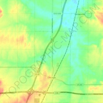
Nom : Carte topographique Checotah, altitude, relief.
Lieu : Checotah, McIntosh County, Oklahoma, 74426, United States (35.44943 -95.54899 35.53302 -95.50439)
Altitude moyenne : 189 m
Altitude minimum : 168 m
Altitude maximum : 216 m
Autres cartes topographiques
Cliquez sur une carte pour visualiser sa topographie, son altitude et son relief.
Honey Springs Battlefield
United States > Oklahoma > McIntosh County > Rentiesville
Altitude moyenne : 185 m