
Carte topographique Marktoberdorf
Carte interactive
Cliquez sur la carte pour afficher l’altitude.
À propos de cette carte
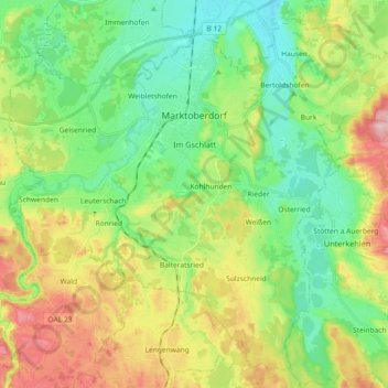
Nom : Carte topographique Marktoberdorf, altitude, relief.
Lieu : Marktoberdorf, Landkreis Ostallgäu, Bayern, 87616, Deutschland (47.69431 10.52981 47.80565 10.71268)
Altitude moyenne : 770 m
Altitude minimum : 704 m
Altitude maximum : 888 m
Autres cartes topographiques
Cliquez sur une carte pour visualiser sa topographie, son altitude et son relief.
Pfronten
Deutschland > Bayern > Landkreis Ostallgäu
Pfronten, Landkreis Ostallgäu, Bayern, 87459, Deutschland
Altitude moyenne : 1 085 m
Füssen
Deutschland > Bayern > Landkreis Ostallgäu
Füssen, Landkreis Ostallgäu, Bayern, 87629, Deutschland
Altitude moyenne : 852 m