
Faire un don
Équipez-vous pour votre prochaine aventure :
En tant que Partenaire Amazon, ce site perçoit une commission sur les achats éligibles sans surcoût pour vous.
Carte topographique Cumbernauld
Cliquez sur la carte pour afficher l’altitude.
Faire un don
Équipez-vous pour votre prochaine aventure :
En tant que Partenaire Amazon, ce site perçoit une commission sur les achats éligibles sans surcoût pour vous.
Cumbernauld
Cumbernauld's name probably comes from the Gaelic comar nan allt, meaning "meeting of the burns or streams". There are differing views as to the etymology of this. One theory is that from its high point in the Central Belt, its streams flow both west to the River Clyde and east to the Firth of Forth so Cumbernauld's name is about it being on a watershed. Another theory ascribes the name to the meeting point of the Red Burn and Bog Stank streams within Cumbernauld Glen. 'Cumbernauld' is generally considered to be a Gaelic name. However, early forms containing Cumyr- hint at a Cumbric predecessor derived from *cömber, 'confluence' (c.f Welsh cymer, 'confluence'), synonymous with Aber. This seems to be suffixed with Cumbric *-ïn-alt, a topographical suffix perhaps referring to a hill or slope (Welsh yn allt, 'at a hill').
Faire un don
Équipez-vous pour votre prochaine aventure :
En tant que Partenaire Amazon, ce site perçoit une commission sur les achats éligibles sans surcoût pour vous.
À propos de cette carte
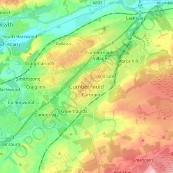
Nom : Carte topographique Cumbernauld, altitude, relief.
Altitude moyenne : 111 m
Altitude minimum : 37 m
Altitude maximum : 223 m
Faire un don
Équipez-vous pour votre prochaine aventure :
En tant que Partenaire Amazon, ce site perçoit une commission sur les achats éligibles sans surcoût pour vous.