
Carte topographique Victoria Peak Lookout (over the Victoria Harbour)
Carte interactive
Cliquez sur la carte pour afficher l’altitude.
À propos de cette carte
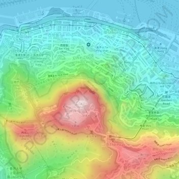
Nom : Carte topographique Victoria Peak Lookout (over the Victoria Harbour), altitude, relief.
Altitude moyenne : 191 m
Altitude minimum : -2 m
Altitude maximum : 534 m
Autres cartes topographiques
Cliquez sur une carte pour visualiser sa topographie, son altitude et son relief.
扯旗山 Victoria Peak
China > Hongkong > Hong Kong Island
扯旗山 Victoria Peak, Hong Kong Island, Hongkong, China
Altitude moyenne : 209 m
Southern District
China > Hongkong > Hong Kong Island
Southern District, Hong Kong Island, Hongkong, China
Altitude moyenne : 36 m
中區 Central District
China > Hongkong > Hong Kong Island
中區 Central District, Hong Kong Island, Hongkong, China
Altitude moyenne : 114 m