
Carte topographique Central Milton Keynes
Carte interactive
Cliquez sur la carte pour afficher l’altitude.
À propos de cette carte
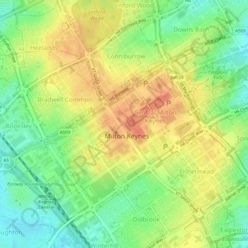
Nom : Carte topographique Central Milton Keynes, altitude, relief.
Altitude moyenne : 97 m
Altitude minimum : 73 m
Altitude maximum : 118 m
Autres cartes topographiques
Cliquez sur une carte pour visualiser sa topographie, son altitude et son relief.
Woughton on the Green
United Kingdom > England > Milton Keynes
Woughton on the Green, Milton Keynes, South East, England, United Kingdom
Altitude moyenne : 87 m
Loughton and Great Holm
United Kingdom > England > Milton Keynes
Loughton and Great Holm, Milton Keynes, South East, England, United Kingdom
Altitude moyenne : 92 m