Géolocaliser

Carte topographique Cumberland County

Carte interactive

Cliquez sur la carte pour afficher l’altitude.

À propos de cette carte

Nom : 
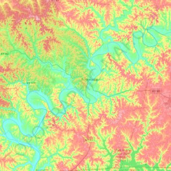
Carte topographique Cumberland County, altitude, relief.

Lieu : Cumberland County, Kentucky, United States of America (36.61853 -85.60121 36.93842 -85.21472)

Altitude moyenne : 237 m

Altitude minimum : 157 m

Altitude maximum : 344 m

Autres cartes topographiques

Cliquez sur une carte pour visualiser sa topographie, son altitude et son relief.

High Plains

United States of America > Kentucky > High Plains

High Plains, Breckinridge County, Kentucky, 40115, United States of America

Altitude moyenne : 228 m

Covington

United States of America > Kentucky > Covington

Covington, Kenton County, Kentucky, United States of America

Altitude moyenne : 215 m

Pineville

United States of America > Kentucky > Pineville

Pineville, Bell County, Kentucky, United States of America

Altitude moyenne : 426 m

Ready

United States of America > Kentucky > Ready

Ready, Grayson County, Kentucky, United States of America

Altitude moyenne : 206 m

Monroe County

United States of America > Kentucky

Monroe County, Kentucky, United States of America

Altitude moyenne : 250 m

Pomp

United States of America > Kentucky > Pomp

Pomp, Morgan County, Kentucky, 41472, United States of America

Altitude moyenne : 282 m

Lawrenceburg

United States of America > Kentucky > Lawrenceburg > Lawrenceburg

Lawrenceburg, Anderson County, Kentucky, 40342, United States of America

Altitude moyenne : 244 m

Millard

United States of America > Kentucky > Millard

Nelse, Millard, Pike County, Kentucky, 41562, United States of America

Altitude moyenne : 315 m

Metcalfe County

United States of America > Kentucky

Metcalfe County, Kentucky, United States of America

Altitude moyenne : 251 m