
Carte topographique Lüneburg
Carte interactive
Cliquez sur la carte pour afficher l’altitude.
À propos de cette carte
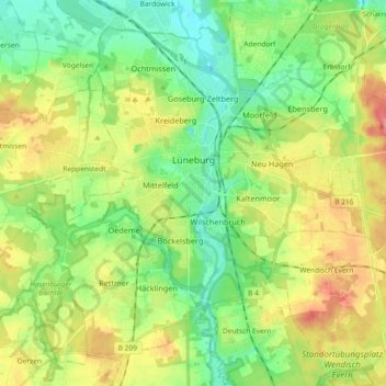
Nom : Carte topographique Lüneburg, altitude, relief.
Lieu : Lüneburg, Lower Saxony, Germany (53.19168 10.33083 53.28664 10.51436)
Altitude moyenne : 35 m
Altitude minimum : 5 m
Altitude maximum : 82 m
Autres cartes topographiques
Cliquez sur une carte pour visualiser sa topographie, son altitude et son relief.
Horburg
Germany > Lower Saxony > Lüneburg
Horburg, Barum, Samtgemeinde Bardowick, Lüneburg, Lower Saxony, 21395, Germany
Altitude moyenne : 5 m
Rassau
Germany > Lower Saxony > Lüneburg > Amt Neuhaus
Rassau, Amt Neuhaus, Lüneburg, Lower Saxony, 29456, Germany
Altitude moyenne : 17 m