
Carte topographique Ardgillan Demesne
Carte interactive
Cliquez sur la carte pour afficher l’altitude.
À propos de cette carte
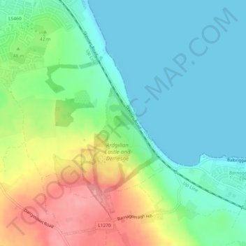
Nom : Carte topographique Ardgillan Demesne, altitude, relief.
Altitude moyenne : 32 m
Altitude minimum : 0 m
Altitude maximum : 95 m
Autres cartes topographiques
Cliquez sur une carte pour visualiser sa topographie, son altitude et son relief.
Ardgillan Castle
Ardgillan Castle, Lady's Stairs, Ardgillan Demesne, Balbriggan ED, Balrothery, Fingal, County Dublin, Leinster, K34 FC43, Ireland
Altitude moyenne : 43 m