
Carte topographique Cranmore
Cliquez sur la carte pour afficher l’altitude.
À propos de cette carte
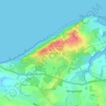
Nom : Carte topographique Cranmore, altitude, relief.
Altitude moyenne : 12 m
Altitude minimum : -3 m
Altitude maximum : 61 m
Autres cartes topographiques
Cliquez sur une carte pour visualiser sa topographie, son altitude et son relief.
Ventnor
United Kingdom > England > Isle of Wight
Ventnor's landmarks arise from its natural environment, its Victorian heritage, and its tourist appeal past and present. Although modest in altitude at 241 metres (791 ft), the chalk St Boniface Down is 1⁄2 mile (0.80 km) north of the town. The downs have a thick layer of acid flint gravels, with dry…
Altitude moyenne : 58 m
Bembridge
United Kingdom > England > Isle of Wight
Close to the lifeboat station lies a coastguard lookout. Positioned at a high elevation, this offers views of the Solent meeting the English Channel to the east of the Isle of Wight. From this vantage point one is able to view a variety of watercraft year round, although there is more marine traffic in the…
Altitude moyenne : 9 m
Isle of Wight National Landscape
United Kingdom > England > Isle of Wight > Brighstone
Altitude moyenne : 18 m
Lake
United Kingdom > England > Isle of Wight
Lake is a seaside village situated above the cliffs on Sandown bay, it stands at an elevation of 63 feet (19 m) above sea-level. Lake's beach or 'Welcome Beach' has golden sands and reached by a steep path down the sandstone cliffs to the Revetment. It has two cafes (Hinks and Strollers), beach huts, a Sea…
Altitude moyenne : 13 m