
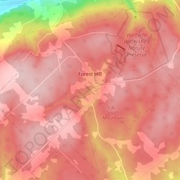
Carte topographique Forest Hill
Carte interactive
Cliquez sur la carte pour afficher l’altitude.
À propos de cette carte
Nom : Carte topographique Forest Hill, altitude, relief.
Altitude moyenne : 184 m
Altitude minimum : 17 m
Altitude maximum : 237 m
Autres cartes topographiques
Cliquez sur une carte pour visualiser sa topographie, son altitude et son relief.
Canning
Canada > Nova Scotia > Municipality of the County of Kings
Canning, Municipality of the County of Kings, Kings County, Nova Scotia, B0P 1H0, Canada
Altitude moyenne : 22 m
Ross Creek
Canada > Nova Scotia > Municipality of the County of Kings
Ross Creek, Municipality of the County of Kings, Kings County, Nova Scotia, B0P 1H0, Canada
Altitude moyenne : 100 m
Tremont
Canada > Nova Scotia > Municipality of the County of Kings
Tremont, Municipality of the County of Kings, Kings County, Nova Scotia, B0P 1R0, Canada
Altitude moyenne : 58 m
Greenwood
Canada > Nova Scotia > Municipality of the County of Kings
Greenwood, Municipality of the County of Kings, Kings County, Nova Scotia, B0P 1N0, Canada
Altitude moyenne : 28 m