
Carte topographique Porterville
Carte interactive
Cliquez sur la carte pour afficher l’altitude.
Porterville
Porterville, lying along the foothills of the Sierras at an elevation of 455 feet (139 m), is located on State Highway 65, 165 miles (266 km) north of Los Angeles, and 171 miles (275 km) east of the Pacific Coast. The city has a strategic central location to major markets and a ready access to major transportation routes.
À propos de cette carte
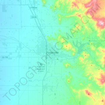
Nom : Carte topographique Porterville, altitude, relief.
Altitude moyenne : 222 m
Altitude minimum : 95 m
Altitude maximum : 1 003 m