
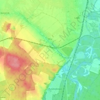
Carte topographique Wiry
Carte interactive
Cliquez sur la carte pour afficher l’altitude.
À propos de cette carte
Nom : Carte topographique Wiry, altitude, relief.
Altitude moyenne : 81 m
Altitude minimum : 47 m
Altitude maximum : 128 m
Autres cartes topographiques
Cliquez sur une carte pour visualiser sa topographie, son altitude et son relief.
Poznań
Poland > Greater Poland Voivodeship > Poznań County
Poznań, Poznań County, Greater Poland Voivodeship, Poland
Altitude moyenne : 85 m
Mosina
Poland > Greater Poland Voivodeship > Poznań County
Mosina, gmina Mosina, Poznań County, Greater Poland Voivodeship, 62-050, Poland
Altitude moyenne : 71 m
Stęszew
Poland > Greater Poland Voivodeship > Poznań County
Stęszew, gmina Stęszew, Poznań County, Greater Poland Voivodeship, Poland
Altitude moyenne : 76 m
Będlewo
Poland > Greater Poland Voivodeship > Poznań County
Będlewo, gmina Stęszew, Poznań County, Greater Poland Voivodeship, Poland
Altitude moyenne : 73 m
Komorniki
Poland > Greater Poland Voivodeship > Poznań County
Komorniki, gmina Komorniki, Poznań County, Greater Poland Voivodeship, 62-052, Poland
Altitude moyenne : 84 m
Poznań
Poland > Greater Poland Voivodeship > Poznań County
Poznań, Poznań County, Greater Poland Voivodeship, Poland
Altitude moyenne : 85 m
Trzebaw
Poland > Greater Poland Voivodeship > Poznań County
Trzebaw, gmina Stęszew, Poznań County, Greater Poland Voivodeship, Poland
Altitude moyenne : 79 m
Buk
Poland > Greater Poland Voivodeship > Poznań County > Buk
Buk, gmina Buk, Poznań County, Greater Poland Voivodeship, Poland
Altitude moyenne : 86 m
Swarzędz
Poland > Greater Poland Voivodeship > Poznań County > Swarzędz
Swarzędz, gmina Swarzędz, Poznań County, Greater Poland Voivodeship, 62-020, Poland
Altitude moyenne : 87 m
Luboń
Poland > Greater Poland Voivodeship > Poznań County > Luboń
Luboń, Poznań County, Greater Poland Voivodeship, Poland
Altitude moyenne : 74 m
Przeźmierowo
Poland > Greater Poland Voivodeship > Poznań County > Przeźmierowo
Przeźmierowo, gmina Tarnowo Podgórne, Poznań County, Greater Poland Voivodeship, 62-081, Poland
Altitude moyenne : 91 m