
Carte topographique Trigg County
Carte interactive
Cliquez sur la carte pour afficher l’altitude.
À propos de cette carte
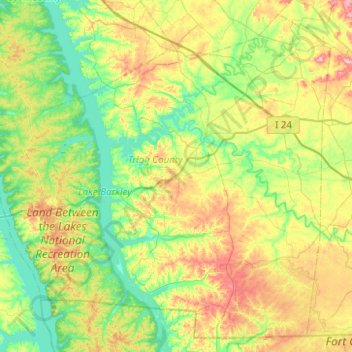
Nom : Carte topographique Trigg County, altitude, relief.
Lieu : Trigg County, Kentucky, United States (36.63475 -88.15775 37.00209 -87.66000)
Altitude moyenne : 150 m
Altitude minimum : 101 m
Altitude maximum : 247 m
Autres cartes topographiques
Cliquez sur une carte pour visualiser sa topographie, son altitude et son relief.
Louisville
United States > Kentucky > Jefferson County
Louisville, Jefferson County, Kentucky, United States
Altitude moyenne : 188 m
Liberty
United States > Kentucky > Casey County
Liberty, Casey County, Kentucky, United States
Altitude moyenne : 276 m
Villa Hills
United States > Kentucky > Kenton County
Villa Hills, Kenton County, Kentucky, United States
Altitude moyenne : 224 m
La Grange
United States > Kentucky > Oldham County
La Grange, Oldham County, Kentucky, 40031, United States
Altitude moyenne : 246 m
Lexington
United States > Kentucky > Fayette County
Lexington, Fayette County, Kentucky, United States
Altitude moyenne : 281 m
Mayfield
United States > Kentucky > Graves County
Mayfield, Graves County, Kentucky, 42066, United States
Altitude moyenne : 145 m
Campton
United States > Kentucky > Wolfe County
Campton, Wolfe County, Kentucky, United States
Altitude moyenne : 323 m
New
United States > Kentucky > Owen County
New, Owen County, Kentucky, United States
Altitude moyenne : 243 m
Ninevah
United States > Kentucky > Anderson County > Ninevah
Ninevah, Anderson County, Kentucky, United States
Altitude moyenne : 237 m
Clifton
United States > Kentucky > Jefferson County > Louisville > Clifton
Clifton, Louisville, Jefferson County, Kentucky, 40206, United States
Altitude moyenne : 147 m
Forest Hills
United States > Kentucky > Forest Hills
Forest Hills, Jefferson County, Kentucky, United States
Altitude moyenne : 202 m
Fort Thomas
United States > Kentucky > Fort Thomas
Fort Thomas, Campbell County, Kentucky, 41075, United States
Altitude moyenne : 192 m
Baptist
United States > Kentucky > Baptist
Baptist, Wolfe County, Kentucky, 41301, United States
Altitude moyenne : 320 m