
Carte topographique Overstrand Ward 10
Carte interactive
Cliquez sur la carte pour afficher l’altitude.
À propos de cette carte
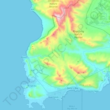
Nom : Carte topographique Overstrand Ward 10, altitude, relief.
Altitude moyenne : 213 m
Altitude minimum : -1 m
Altitude maximum : 1 253 m
Autres cartes topographiques
Cliquez sur une carte pour visualiser sa topographie, son altitude et son relief.
Overstrand Ward 8
RSA > Western Cape > Overstrand Local Municipality
Overstrand Ward 8, Overstrand Local Municipality, Overberg District Municipality, Western Cape, RSA
Altitude moyenne : 144 m
Walker Bay Nature Reserve
RSA > Western Cape > Overstrand Local Municipality
Walker Bay Nature Reserve, Overstrand Ward 11, Overstrand Local Municipality, Overberg District Municipality, Western Cape, RSA
Altitude moyenne : 54 m
Maanschynkop Nature Reserve
RSA > Western Cape > Overstrand Local Municipality
Maanschynkop Nature Reserve, R43, Overstrand Ward 3, Overstrand Local Municipality, Overberg District Municipality, Western Cape, 7210, RSA
Altitude moyenne : 538 m
Rooiels River
RSA > Western Cape > Overstrand Local Municipality
Rooiels River, Overstrand Local Municipality, Overberg District Municipality, Western Cape, RSA
Altitude moyenne : 103 m
Fernkloof Nature Reserve
RSA > Western Cape > Overstrand Local Municipality
Fernkloof Nature Reserve, Rotary Way Extension, Overstrand Ward 3, Overstrand Local Municipality, Overberg District Municipality, Western Cape, 7200, RSA
Altitude moyenne : 237 m
Three Sisters
RSA > Western Cape > Overstrand Local Municipality
Three Sisters, Overstrand Local Municipality, Overberg District Municipality, Western Cape, 7195, RSA
Altitude moyenne : 306 m
Salmonsdam Nature Reserve
RSA > Western Cape > Overstrand Local Municipality
Salmonsdam Nature Reserve, Salmonsdam Nature Reserve 4x4 Trail, Cape Agulhas Ward 1, Overstrand Local Municipality, Overberg District Municipality, Western Cape, RSA
Altitude moyenne : 343 m
Boesmans River
RSA > Western Cape > Overstrand Local Municipality
Boesmans River, Overstrand Local Municipality, Overberg District Municipality, Western Cape, 7271, RSA
Altitude moyenne : 121 m
Quoin Point Nature Reserve
RSA > Western Cape > Overstrand Local Municipality
Quoin Point Nature Reserve, R43, Overstrand Ward 11, Overstrand Local Municipality, Overberg District Municipality, Western Cape, RSA
Altitude moyenne : 12 m