
Carte topographique Oberes Dorf
Carte interactive
Cliquez sur la carte pour afficher l’altitude.
À propos de cette carte
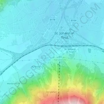
Nom : Carte topographique Oberes Dorf, altitude, relief.
Altitude moyenne : 711 m
Altitude minimum : 649 m
Altitude maximum : 1 004 m
Autres cartes topographiques
Cliquez sur une carte pour visualiser sa topographie, son altitude et son relief.
Almdorf
Österreich > Tirol > Bezirk Kitzbühel > Marktgemeinde St. Johann in Tirol
Almdorf, Marktgemeinde St. Johann in Tirol, Bezirk Kitzbühel, Tirol, 6380, Österreich
Altitude moyenne : 728 m
Scheffau
Österreich > Tirol > Bezirk Kitzbühel > Marktgemeinde St. Johann in Tirol
Scheffau, Marktgemeinde St. Johann in Tirol, Bezirk Kitzbühel, Tirol, Österreich
Altitude moyenne : 939 m