
Carte topographique Río Ibáñez
Carte interactive
Cliquez sur la carte pour afficher l’altitude.
À propos de cette carte
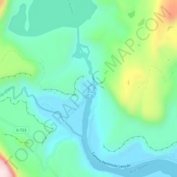
Nom : Carte topographique Río Ibáñez, altitude, relief.
Altitude moyenne : 314 m
Altitude minimum : 203 m
Altitude maximum : 655 m
Autres cartes topographiques
Cliquez sur une carte pour visualiser sa topographie, son altitude et son relief.
Lago Lapparent
Chile > Región Aysén del General Carlos Ibáñez del Campo > Río Ibáñez
Lago Lapparent, Cruce Ruta 7 - Lago Las Ardillas - Cruce X-735 (Cruce Levicán), Río Ibáñez, Provincia de General Carrera, Región Aysén del General Carlos Ibáñez del Campo, Chile
Altitude moyenne : 931 m
Parque Nacional Cerro Castillo
Chile > Región Aysén del General Carlos Ibáñez del Campo > Río Ibáñez
Parque Nacional Cerro Castillo, Río Ibáñez, Provincia de General Carrera, Región Aysén del General Carlos Ibáñez del Campo, Chile
Altitude moyenne : 970 m