
Carte topographique North Cowichan
Carte interactive
Cliquez sur la carte pour afficher l’altitude.
À propos de cette carte
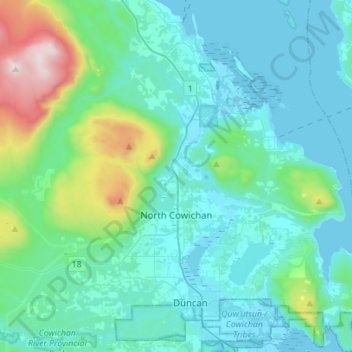
Nom : Carte topographique North Cowichan, altitude, relief.
Altitude moyenne : 180 m
Altitude minimum : -1 m
Altitude maximum : 1 186 m
Autres cartes topographiques
Cliquez sur une carte pour visualiser sa topographie, son altitude et son relief.
Cowichan River
Canada > Colombie-Britannique > Cowichan Valley Regional District > Area F (Cowichan Lake South / Skutz Falls)
Cowichan River, Area F (Cowichan Lake South / Skutz Falls), Cowichan Valley Regional District, Colombie-Britannique, Canada
Altitude moyenne : 196 m